ok, I ll double check just not to bother.
I checked the result of your import. The data were imported correctly. They are simply very far away from the center of the Blender global coordinate system. The reason for that behavior and how to avoid it is given below.
To see your data select the Blender object with imported buildings parented under the Blender EMPTY object. Press . (period) on the numpad of your keyboard to zoom to the imported buildings.
After the first OSM import the addon sets geographical coordinates of the center of the Blender global coordinate system as custom attributes of the current Blender scene. All subsequent OSM imports will be made relative to that point. So if an area from your second import is hundred miles away from the first import, it will placed hundred miles away from the center of the Blender global coordinate system. You could either start a clean Blender scene to avoid that affect or check the addon GUI setting Ignore existing georeferencing. The setting is also described in the documentation https://github.com/vvoovv/blender-osm/wiki/Documentation.
Thanks for quick and comprehensive response, seems fine now.
Btw. Always wondered why clipping planes could not be set to imported objects accordingly? So a user would not have to guess whats
still a disabled option left that prevents Blender from working/displaying as expected…))
Of course ![]() Can’t wait for it to be released.
Can’t wait for it to be released.
thank you so much for the latest update!
pretty cool and working great so far
what i really would like to be super-happy about would be some kind of roof-height randomizer/jitter. like ±1 level number or ± meter
parameter. that could add great detail to the generic houses 
thanks again
Lasse
I am working on the premium version. I decided to make texturing of buildings the key feature of the first release of the premium version.
Random height for buildings will be implemented after the first release of the premium version for both base and premium versions. However there is a chance that random height for buildings will be implemented earlier if that feature helps textured buildings to look more realistic.
A way to paint height and roofs would also be awesome (select gabled and just click once on every house that has such a roof). Like the NP_Station material paint tool, but to add or remove levels and change roof type, it would allow to quickly give the right look to the town’s building.
Then, a way to update the OSM database with the new levels number and roof types would be awesome. At the moment, although your addon has an awesome potential, datas are missing. An “upload changes” operator would help to make your addon more attractive, by having a bigger community to enhance the OSM database.
Just tried the NP_shader_brush from the NP_Station addon. It will be a really handy operator for textured buildings!
I am missing a Blender editor for OSM 3D buildings too. However a full fledge OSM editor inside Blender would be a complex task, since it must have a conflict resolution tool for the case when someone edited your area of interest at the same time as you and uploaded the changes to the OSM server before you. An OSM file with changes can be exported from Blender and opened in the JOSM (the desktop application for OSM editing) for final uploading to the OSM database.
Great if we can have OSM export ![]() If there is a little of manual work to upload, it’s ok. For conflicts, the uploads have to be accepted anyway, so I see more of a chance to grow the database faster here. I really would concentrate on height and roof for the data to be updated, for the rest, there are tons of good editors out there. The brush could also have the levels number set with keyboard input (you type 3 then click all the buildings with 3 levels, type 2 and click all the buildings with 2 levels, etc.) It would make updating town’s data really fast.
If there is a little of manual work to upload, it’s ok. For conflicts, the uploads have to be accepted anyway, so I see more of a chance to grow the database faster here. I really would concentrate on height and roof for the data to be updated, for the rest, there are tons of good editors out there. The brush could also have the levels number set with keyboard input (you type 3 then click all the buildings with 3 levels, type 2 and click all the buildings with 2 levels, etc.) It would make updating town’s data really fast.
@bliblubli
Actually building height, number of levels and roof shape can be easily set in JOSM (the desktop application for OSM editing).
It supports editing of tags for multiple selected objects.
The tags height, building:levels and roof:shape are responsible for the building height, number of levels and roof shape respectively.
Yeah, I know but setting data without any visual feedback is prompt to errors nobody will ever see. And doing the whole process in 3D gives you instant feedback, you can have google earth or your photos on half of the screen, Blender on the other, and instantly reproduce and visualize the result. I would make a contributor import mode, where building without height information are just flat shapes. We then instantly know where to fill the data missing. But I can understand if you only want to make your addon for users taking data from OpenStreetMap and not for it’s contributors.
Would it be possible to take georef after dxf import into account ? It uses custom scene property SRID, latitude, longitude and altitude. At the moment, both datas are misaligned.
@matali,
you are the first one to request that feature.
So I consider it as a very advanced usage. I’d suggest you to create your own class to deal with projections.
The class must have 2 methods similar to util.transverse_mercator.TransverseMercator
def __init__(self, **kwargs):
    # the constructor
def fromGeographic(self, lat, lon):
    # you projection code here
    return (x, y, z)
Then change the following lines in the to level init.py
if "lat" in scene and "lon" in scene and not a.ignoreGeoreferencing:
    kwargs["projection"] = TransverseMercator(lat=scene["lat"], lon=scene["lon"])
else:
    kwargs["projectionClass"] = TransverseMercator
Substitute TransverseMercator for your own projection class
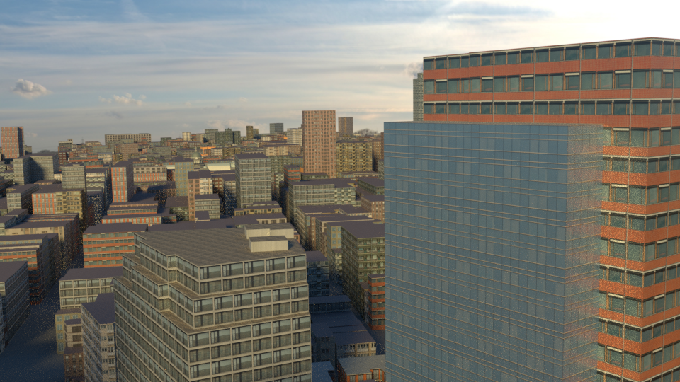
Time to show the progress for the premium version.
The premium version (among the other things) will UV-map OpenStreetMap buildings and apply procedural materials:
1 Like
Good stuff. Is there an ETA on the premium version and price?
@HeadClot
The premium version will released later this fall. There will be a discount for all customers of the blender-osm addon.
I’d prefer not to announce the price right now.
Another feature of the upcoming premium version of the blender-osm addon: satellite imagery projected on the terrain as usual with one click:

1 Like
woow!
looking good!
WOW! Itching to get my hands on this!