Hi @serviteur,
I need additional information to answer your question. Could you please provide a picture to illustrate what contour map/contour generator is?
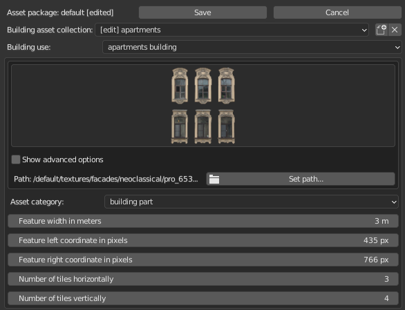
The most beneficial way for the community would be to add the information about the number of floors and roof types to the OpenStreetMap database. It isn’t that difficult. Open https://osm.org. Zoom to your area of interest and press the Edit tab. Select a building footprint and add:
building:levels = [number of floors]
roof:shape = [gabled or flat or hipped]
Having said that, I must note that it’s possible to set the average height for your area of interest in the experimental mode via the PML style mentioned above.
For example, for the appartments buildings open [your assets folder]/default/style/building/residential.pml. Then take the look at line 11:
footprint{
    numLevels: attr("building:levels") | if (not item["height"]) random_weighted( (4, 10), (5, 40), (6, 10) );
}
That means take the number of levels from the OSM attribute building:levels. If the attribute isn’t provided and there is no OSM height attribute, chose the number of levels randomly:
4 storeyed building has the relative weight 10
5 storeyed building has the relative weight 40
6 storeyed building has the relative weight 10
In other words 40 buildings out of each 10+40+10=60 buildings will have 5 floors, 10 building out of each 60 buildings will have 4 floors and finally the remaing 10 building will have 6 floors.
2 Likes
A tool that automates generate contour map/line map from 3D terrain.
Some examples for generate manually:
-
https://blender.stackexchange.com/questions/120342/create-topography-map-lines
-
https://designerhacks.com/how-to-generate-a-contour-map-with-sketchup/
TopoShaper in Sketchup | Plugin for Contours
1 Like
Received. Thank you for your answer.
Dear Vladimir,
i have a question about the georef in BlenderOSM. I import some samples to test the addon and I stumbled upon something I can’t get resolved.
My approach:
I prepare a area as building in EPSG 32633 to import it with your addon. The area is square with equal sides. When i import it into blender i noticed a slight rotation and the sides are not longer equal.
To compare the problem, i import the area also with blenderGIS. The values are correct here.
Any ideas how to get the correct georef for the import? I have read your georef on git from 2016 and the osm_georeferencing.py, but i thought this is outdated and not longer needed. It would be great if you give me a hint.
Best Regards
Markus
Hi @MarkusM,
Please note that the tab Geoscene is created by BlenderGIS. It isn’t a built-in Blender tab. So the Blender-OSM addon can’t now anything about a projection set in the Geoscene tab.
By default the Blender-OSM addon imports data in the transverse Mercator projection. To import OSM data in a custom projection please follow the instructions here. The projection code (SRID) would be EPSG:32633 for your case.
1 Like
Thank you for the prompt answer. I will try it with pyproj and SRID or Proj4 +proj=utm +zone=33 +ellps=WGS84 +datum=WGS84 +units=m +no_defs
1 Like
Working on GUI to set custom facade textures and texture atlases.
7 Likes
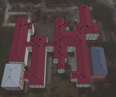
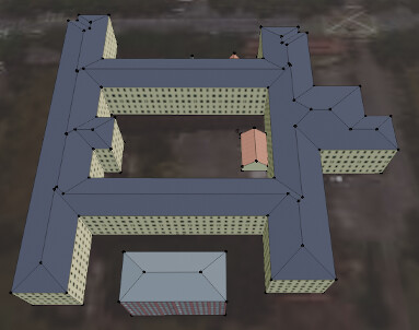
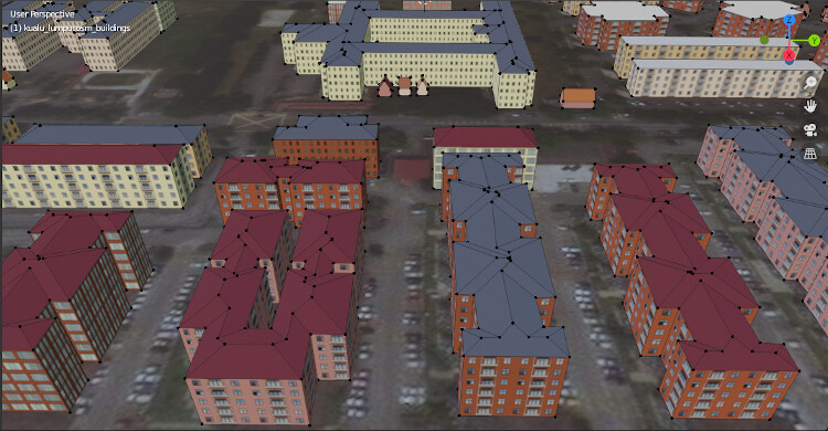
Complex hipped roofs are now supported by Blender-OSM addon. Tested for all 320.000 hipped roofs in OpenStreetMap. The addon successfully treats 99.99% of them.
The feature is currently available in the experimental mode of the premium version. Get the latest version using the download link in your purchase confirmation email. Update of assets is also required.
4 Likes
There were requests where to find hipped roofs at OpenStreetMap to test the latest feature of Blender-OSM. Here is a district in Kuala Lumpur densely packed with all kinds of hipped roofs: 101.5880,3.0421,101.5942,3.0488
Copy the coordinates to the clipboard and press the button “paste” in the addon panel. Don’t forget to enable the “experimental features” mode in the Blender-OSM preferences.
3 Likes
Hi Vladimir,
I really love this tool!
Just now it starts crashing on me (blender closes without warning) just after finishing fetching the image overlay tiles.
- Is there any info I could provide you to figure out why / to fix this?
- Also, since downloading the tiles takes so long, is there a way to use the cache (the preferences’ “Directory to store downloaded …”) and use the tiles already downloaded? It always starts downloading anew …
- [feature request: be able to cancel tiles download]
(If there is anything about these questions in the doc that I haven’t found, I apologize.)
Thank you very much in advance! 
Hi @ug_ffm
Could you please send me a private message with a screenshot of the import settings that lead to the Blender crash? I’d like to reproduce the problem.
Cashing is done from the first release of the imagery import:

Ups, sorry – yes, now I see it indeed caching; I was misguided because the speed of going through the tiles was not very noticeably different from downloading …
Because of my current user status, I cannot yet send you pm’s, sorry.
So instead here my “Crash To Desktop” description:
For an animation with a big change in screen percentage of the model (a long dolly/flight), and without wanting to manually separate the landscape into many smaller-sized areas to layer on top or stitch together, I wanted to try to texture to the highest resolution available from the provider.
The CTD occurs when too many tiles have been fetched, and seemingly at the point when they are made into a material.
Before the crash, the plugin downloads all tiles – I can see them in the cache directory.
Examples of my settings for “max number of tiles”, the number of tiles downloading from the server, and the result:
Max tiles: 9000; ArcGIS: 8928 tiles => CTD
Max tiles: 5000; ArcGIS: 2256 tiles => CTD
Max tiles: 2500; ArcGIS: 2256 tiles => CTD
Max tiles: 2500; Mapbox: 2256 tiles => CTD
Max tiles: 2000; ArcGIS: 600 tiles => success
Max tiles: 2000; Mapbox: 600 tiles => success
@ug_ffm, thank you for the detailed report.
The crash happens when the tiles are stitched together because Blender runs out of memory. The workaround would be to divide the terrain to at least 4 parts and get the overlay texture for each terrain part separately. An alternative solution is described at blender.stackexchange.com.
Hi,
I’ve purchased the premium-version and run in trouble when i import the generated terrain in Godot Engine. Should be .obj or .mesh file. Does some one has a solution or flowchart how to get this things done?
Thx, Rob
Hi @RobMitch
Thank you very much for purchasing the addon!
There is the documentation for the addon.
What was wrong with the import of the terrain to Godot Engine?
Hi vvoovv,
look at the image:
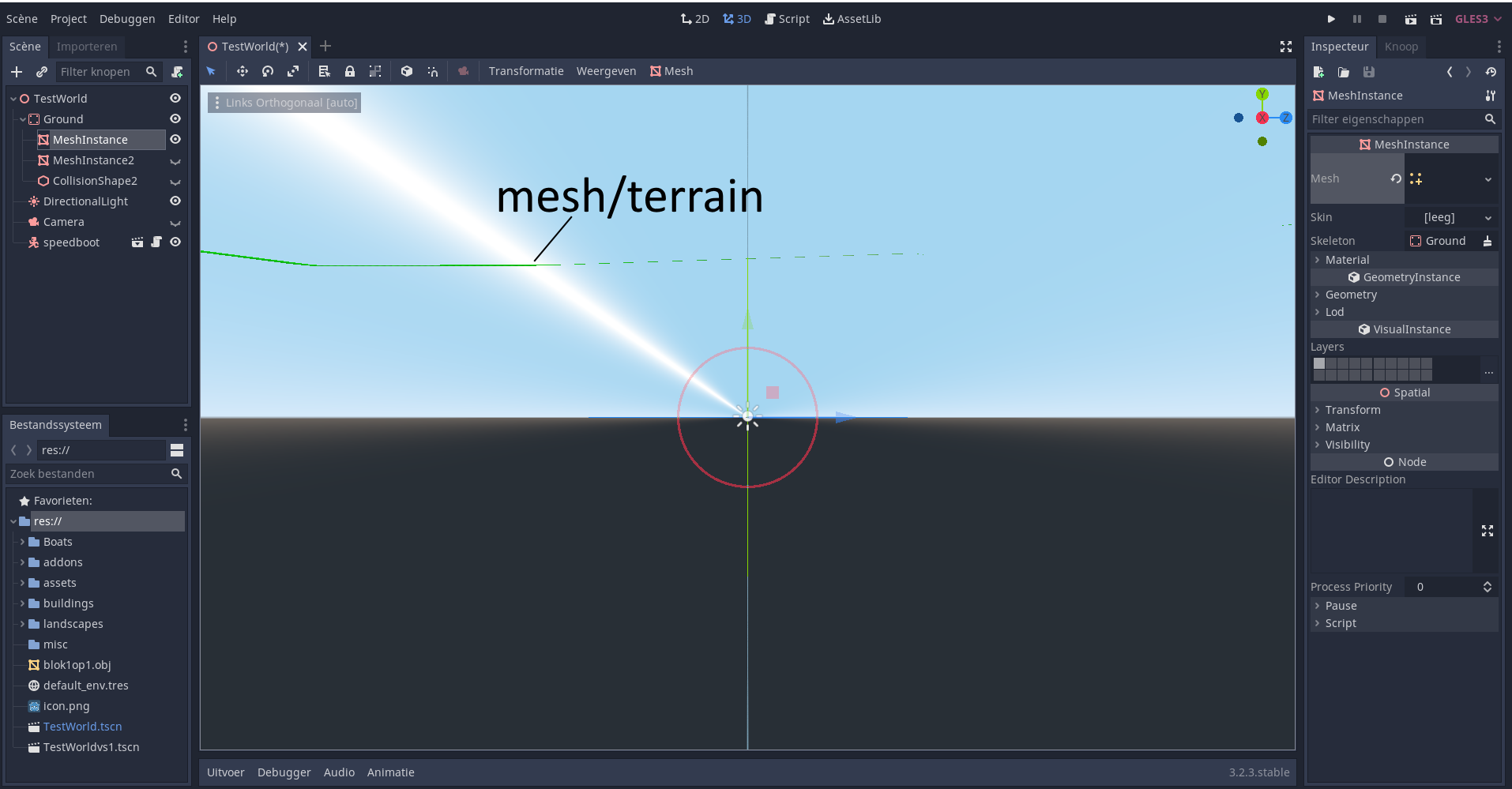
Is it possible to create imediatly a 3d object with on top the form of your mesh?
I need to import it as (.obj, or .mesh or .res file)
It is a wonderfull addon and I’m sure it goes fast to produce beautiful scenery
thx in advance,
Rob
I imported a terrain with the Blender-OSM addon, then exported it to an OBJ file. Then I opened it in Pain3D (a standard Microsoft Windows application). It looks ok in Paint3D:
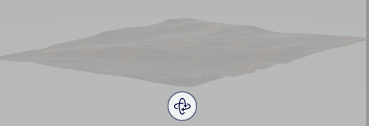
Can you open your OBJ terrain in another application?