Hi, maybe you could help me somehow with a hint…
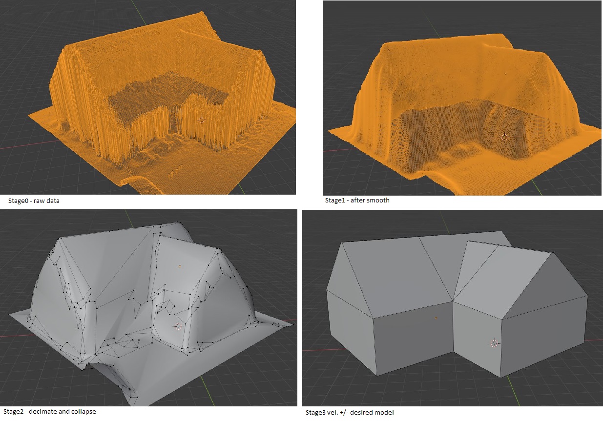
My aim is to recreate building and ground structure based on LIDAR point cloud data to very very simple house models. I am able to create a mesh model (with some ugly artefacts on the edges - but I know I can smooth them) with a thousands of faces. But I’d like to have 10-20-30-50 faces depending on house.
How to do it in the easiest way? As I am aiming in big regions so that redrawing all of the houses is impossible.
I guess it will be something to do with smooth, and decimate modifiers, but maybe there is another, easier way?
I need to do it for few thousand buildings of different shape…
Sure, i did try it in Meshlab with some marshing cubes algorythms and Poisson, as well as in cloud compare with some RANSAC functions, but I feel like I miss a step… I attach LAS file (photogrammetric - not LIDAR), saved as PLY file that could be opened in meshlab without problems. (and raw las file(zipped) as well)example.ply (3.3 MB) example.zip (3.4 MB)
Well, this is surprisingly difficult.
I tried some stuff in Meshlab, but I’ve only had mediocre results.
I did find this project, someone implemented what you’re trying to do (I think) in Unity, which you could try out. Their input looks a lot like your, so it might be worth a try. You just have to extrude the roofs downwards to create walls.
It all depends
There are some open repositories with LAS (Lidar data files) that could be even more accurate. Both for terrain, buildings or some objects.
Data I am working with right now are obtained with processing of drone images. It could be done with both commercial and open software. I started my adventure with that YT film, and then did some tries with bigger objects than in the film. Results could be in a really good quality - like that (Church in Poland or the other one). You could create 3D mesh models from that images as well. Problem is that they could be far too detailed, that could influence the processing and rendering speed (same church as 3D model ) (files in links are possible to download - feel free to play with them
That file I am working with now is created also with drone images taken by my colleagues. They did take only images from top (not many with other angle) so thats why it has not complete facade.