i have a photo of a landscape and i want to show how a proposed photovoltaic installation would look. for now i want a simple answer; is blender the right software or am i wasting my time?
i already have a basic idea of blender and if this photo realistic impression can be done in blender i will invest more time to learn it.
I’m assuming i have to learn camera mapping so i can position things in the real world.
Blender certainly could do the job. For example, if you know the approximate dimensions of the quarry and where the camera placements were, you could now replicate those camera-placements in a pure-digital world. Put planes in space where the floor of the quarry is, put cameras in the right spot (correct lens, tilt, etc…) then place a to-scale model of the photovoltaics at the proper positions on it. Now, do a render (an “OpenGL Quick-Render” will do nicely) which includes the photovoltaics and omits the plane. This can now be composited directly over the existing photographs: just render from the appropriate camera.
That should, fairly quickly, enable you to get your point across to the authorities. And I would strive to keep the whole thing just as simple and to-the-point as you can. Forget the “swooping fly-bys” and “that other Hollywood :ba:,” all of which won’t help them understand what it is that they’re about to approve. Don’t bother to model the quarry itself, unless it’s absolutely mandatory that you show a viewpoint that you don’t have and that you can’t possibly get.
dimesions i can get from google earth, photos i took myself, the only problem is i couldn’t get the elevatation since its a huge quarry and on sloping land
i have about 5 views i need to take and i have photos of all of them
You don’t need to be exact … merely approximate. You simply want to have some reason for confidence that the “virtual camera” location, distances-to-subject, etc. are realistic, so that Blender’s rendition of “an object of that-size, from that point-of-view, in an overall environment of that-size,” will be good-enough.
Blender has no “pre-determined unit of measure,” so you might (arbitrarily) decide that “1 blender-unit = 1 meter” and therefore place the camera “so-many blender-units away from, and so-many blender-units above,” a digital model of a solar-collector that is “so-many blender-units square.” You also need to know, at least, whether the shot was taken with a wide-angle lens or a telephoto.
But it’s worth pondering whether you should learn Blender or not, since it has a very steep learning curve. If you wanna use it for further projects, it’s well worth it, but if you only need it for this specific project, and then never use it again, it’s way too much of an effort.
But it’s worth pondering whether you should learn Blender or not, since it has a very steep learning curve. If you wanna use it for further projects, it’s well worth it, but if you only need it for this specific project, and then never use it again, it’s way too much of an effort.
i want to learn more, i love 3d design, i use acad, sketchup, a bit of solidworks, now i want to add blender to my list
i want to learn more, i love 3d design, i use acad, sketchup, a bit of solidworks, now i want to add blender to my list
Uuuuh. I’m a mechanical engineer, so I know my way around acad and solid works, believe you me, blender is something completely different. But I am however looking forward to see some of your work.
More-or-less, to get “believable-looking” results, you just need to know that the quarry floor was, say, about 250’ below you, that the floor of the room is about 500’ square, and that the panels are going to be roughly in the center. You’ll set up a plane that’s 250 blender-units square, position the camera about 250BU above it, and so on. Putting the original picture as a “backdrop,” you will arrange things so that they look good. You’ll do this for all the camera-positions (and reference photos) such that the same basic set of geometry “looks good” for all of them at the same time.
Talk early, directly, and frequently with whoever-it-is that’s ultimately going to have to walk in front of that council and sell the project.
Uuuuh. I’m a mechanical engineer, so I know my way around Acad and solid Works, believe you me, blender is something completely different. But I am however looking forward to see some of your work.
Actually i’m a mechanical draughtsman and have a diploma in building services, however i love playing around with any software. I learned Sketchup and Solidworks by myself. i have been playing with blender for a long time but never had a project where i could dedicate time lo learn it and be able to use it efficiently
The other problem is I’m always used to modeling accuracy… to the nearest 0.0001mm. That is a habit I need to get out of to use Blender (or any other similar software) efficiently
Ultimately I need more TIME!!! I have my day job and keep up with a part time freelance, doing up the house, spending quality time with the missus and get enough sleep…
Anyway… enough ranting…
sundialsvc4 More-or-less, to get “believable-looking” results, you just need to know that the quarry floor was, say, about 250’ below you, that the floor of the room is about 500’ square, and that the panels are going to be roughly in the center. You’ll set up a plane that’s 250 blender-units square, position the camera about 250BU above it, and so on. Putting the original picture as a “backdrop,” you will arrange things so that they look good. You’ll do this for all the camera-positions (and reference photos) such that the same basic set of geometry “looks good” for all of them at the same time.
Talk early, directly, and frequently with whoever-it-is that’s ultimately going to have to walk in front of that council and sell the project.
Thanks for the tips. Luckily (or unluckily) I am not the one going in front of the planning authority trying to sell the idea however I am getting pushed quite a bit to finish the drawings
I guess it depends on how big the panels are … :eek: … but, “basically, yes.”
What you want Blender to more-or-less do for you is to figure out, based on knowledge of how-big the quarry is and how big the panels are, how they would realistically look from a certain camera-position. Such that, when you composite a 3D image (consisting only of the panels … no backdrop, no “Sky” …) on top of the background image that was taken from that same point-of-view, it will look “good enough for government work.”
Just make sure that the models (a few planes and cylinders) are of the correct relative size, and they’re placed on a 3D plane of the correct size. Make sure the camera position is correct, in Blender terms, in comparison to where the camera was when the reference photo was shot. (Including telephoto lens, etc.) “Decoration,” etc., is pretty-much perfunctory, i.e. unnecessary to convey the point. We just need to see how panels of this size, placed where they’re going to be placed, and viewed from a camera at this position, would approximately look. Human imagination can fill in the blanks.
The first pic you posted of the quarry would be fairly easy to do. You’ve got plenty of lines and flat surfaces that are easy to model. You could use the BLAM add-on to get the position and focal length of the camera.
The second pic of the hill would be a lot more difficult. There aren’t any parallel lines for BLAM to use. Does your camera record the EXIF data so you can get the focal length?
Also, if you want shadows on the ground, you’ll need to make a rough model of the hill to act as a shadow catcher.
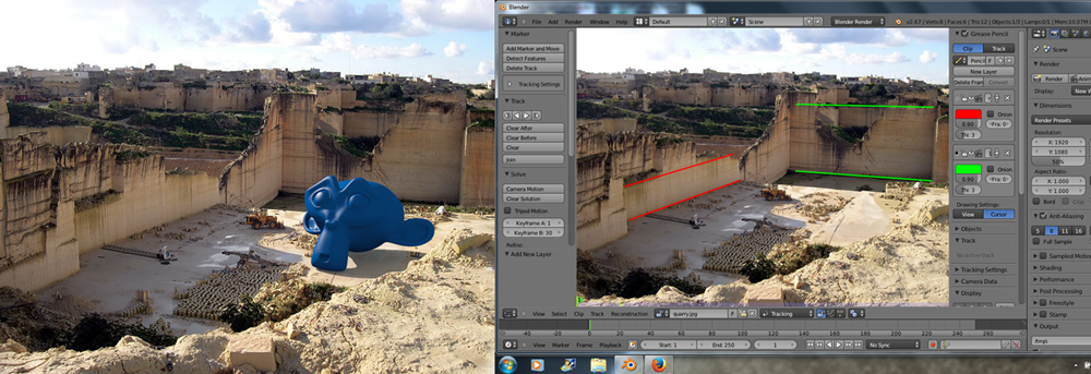
ok so i did an approximate model, though i still have to add materials and other objects such as trees, but the current problem is positioning the model on the image. the cameras are in the right location but cant seem to get things to match up well… does anyone have any hints or suggestions? is there a better way to do it from the link?


