Maritime World of Blender Part 2

By using the decimate function for terrain and replacing the seabed with a 4 vertices sheet I managed to reduce the size to 90,000 vertices form about 130,000. It is a very large route for Blender and had a few tries over the weeks. The decimate function makes all the difference.

No ports or harbours yet but animated a sailing- flat to travel from Port Erin Bay to Port St. Mary bay, 2200 seconds. Might be difficult to find but straight ahead and tucked behind a headland. key 1…
B

Just to add I seem to be moving on to islands as coastal is becoming tedious as regards me using my own routes. So Isle of Man online, seabed removed and replaced with 4 vertices sheet except for margin, decimate used on the terrain. That started at about 44 km size.

Moving up a touch all of Anglesley and the Menai Straits about 47km this one. Started out at 400,000 vertices. Replacing the seabed got it down to about 200,000. Still too high so decimate at 0.65 to about 130,000 vertices triangulated.

Then it took ages to respond. I mistakedly thought it was due to the file size but after a few hours found I had not ticked System/use frame rate/use material caching…seems to work OK for now and will test it a bit before putting it online.

anglesey

1 Like

use material caching needs to be true. otherwise it takes forever like that. no idea why. :slight_smile:

So to keep ’ interested’ myself’, because at present I am finding small size routes are becoming boring, with a few exceptions such as ‘solway’, ‘1800 Mersey’,’ Conwy’. I will need to remake the routes up to about 50 km size which should enable me to include a few ports in each. By replacing the seabed with the flat 4 vertices version and using the decimate function on the srtm2 terrain I can reduce the vertices probably from about 400,000 to below 150,000 hopefully as with the Isle of Man Route. If it works out, I will put a few more online.
No drivable, no animations for dockgates. I will concentrate now only on preset routes between harbours/or in large docks, made with the timeline.

Can ships in preset routes, made with the timeline, be stopped and restarted easily, using the keyboard keys. I can stop and restart them at the quaysides as part of the animation by moving the timeline on and restarting ship in the same position !!. ?

Thanks.
B

1 Like

Updated Isle of Man Route.

(update 19092018)

Tested download and seems to run OK.
Details of each available route will be on my site.

I think with the decimate function, it is now time to travel north along the coastline around the coast of Scotland.

Less developed and not as complex a century or more ago. I will keep the Isle of Man route which will be the starting point. Opposite is the Solway Firth. My ‘solway’ route is at the beginning of Scotland at the head of the Solway Firth and the Annan river I made is in Scotland. Routes would be about 45 to 50km. There are several Scottish islands along the craggy coastline. Also the outer Hebrides.

I think that might be the answer. The Isle of Man and’ Solway’ route can stay online and I will make a leisurely start travelling North with plenty of craggy high ground which makes it easier to make. That might make it more interesting…for me.

B

1 Like

I am not trying to make a sailing simulator as such with game/scenario elements but a virtual ‘glimpse’ of the past maritime coastal ages within the limits of the Blender Game Engine.(2.79)

Please refer to my site for available downloads.
Relevant queries and feedback welcome. NOT required ‘critique’.
Unlikely to keep posting further screenshots and as mentiond please refer to my site for details. Routes are NOT for commercial interests.

B

Thanks

1 Like

Also if you wish post your screenshots of my routes with your own ‘improvements’ to them and explain… for myself and others, all the details of how you achieved the result that you were aiming for. I probably won’t be posting further screenshots.

Routes are and will be probably be 25km to 35 km. Over that size it is difficult to work over an overlay to position objects, ports, etc, as a base map or texture using osm. I will be working on the basic 37 routes already made and maybe later explore the Scottish coastline from Solway Firth. I will update them slowly over a period of time in blocks of five I think with max. of 2 blocks on-line at any one time…if I keep the website.

Routes are NOT for commercial interests.

B

1 Like

X 1,000,000

:broken_heart: :cd:

My reply no longer necessary, see below

http://www.uktrainsim.com/

I will resume posting on the forum that I have posted on for many years. User name is precar and the subforums are Blender and Ship Simulators. It is a train simulator site’

You can find me on the uktrain sim site. You would need to register to post.

B

1 Like

Hopefully UPBGE perhaps as embedded function in Blender of some type it will help to a greater realism for real life simulations…which are my interests. These can take a variety of forms and scenarios(interactive games) can be included in them but more interested in the areas, rivers, etc, myself. However must be embedded for simplicity because of file size of stand alone routes.

Still undecided whether to continue updating the basic details of around quarter of the coastline of the UK… so a continual changing of plans.

I will keep the website until next year and then consider perhaps getting shut of it as I have little interest these days in working on these routes.

just a few routes online but will leave routes on hold for the present time so no point in checking site for updates. B

B

As mentioned unless I can keep myself interested enough, with being the only person I know of making large size simulations in Blender for download, I will call it a day next year when the website is due for renewal…and also abandon the ‘Blender’ ship in one of the creeks.

However found a few more things out for a complete change of tack again which might be enough to keep me interested…if it works.

Many years ago Blender would not even let you place vertices 10,000 meters from either side of the centre as they used to ‘fly back’. We have seen some progress over the years and will see what happens wih UPBGE.

Next route size I managed was up to 44 km with the full Isle of Man… but to maintain interest routes in simulations I think need to be large so trying 75km at 46 miles. There is sequence in the method to use at starts as over, 1,000,000 vertices.

First select and lower the sea to minus 10 meters. make a surround margin at minus 10 to make sure the seabed will slot in…then delete all the sea remaining, so down to 800,000 vertices approx.

With the terrain decimate as before but use un-subdivide with 3 iterations. each iteration halves the vertices/faces. The polygons make a diamond shape which again is useful for the shore and river banks when using smooth vertex.

Slot in a 4 vertices seabed at minus 8 meters height. Sea sheet set animated to rise and fall a meter set at zero height. Still seems to work over the full 75 km as need it to open up rivers as well as sea.

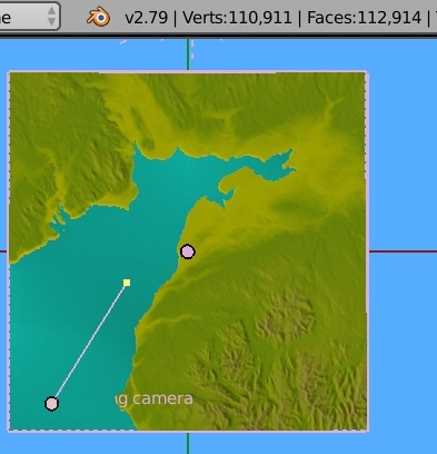
Roaming camera I set at 30 km view which again seems to work OK. vert.sync still at 60.

So hopefully there won’t be dozens of small routes to juggle with. I will leave the full Isle of Man route online and also the full Solway Firth route. I won’t list any further smaller routes only the larger size up 45km to (75 km 46 miles). approx.

Critque is definitely out as there will probably be updates to just a couple of very basic routes from now on. It means remaking dozens to create a much smaller quantity… if it works.

Any trolls just carry on if that makes you happy… and ignored…better still though try a route and let me know of any usefull alterations you make…now that would interesting. (smile).

The route below shows details. Not sure what the max. roaming camera length would be but 30 km seems OK as in screenshot.
So we have the full Isle of Man and the full Solway Firth with the upper shore Scotland.

B

solway_firth_75km

1 Like

60 km seems the better choice as 75km means too much had to be removed. So remade the Isle of Man route as I had seperated the parts. Remade Solway Firth. Started on Cumbria today.

I am going to remove the 3 online and replace them with BASIC 60 km approx routes. Initially they will all be basic, no photo textures, no harbours and no ship routes, probably rivers not created, but sea and estuaries made. Might include one drivable barge (copy and paste).

The aim is to build up the 60km size while 3DEM and computer work OK. Will keep the animated water, rise and fall to a meter height or so ‘IF’ it continues to work. Also will include the roaming- camera. I can always make the water static if problems as more to do with the past ages than Blender and ship simulators.

So if I put 5 online when made, that will be equivalent to about 20 at the 20 to 25km size as depends on terrain shapes.

Then when I have made the basic route ‘library’ I can start to consider what to add.

B

1 Like

03 Cumbria is the third in the series. I cleared out the other routes off my site.As mentioned I will keep to about 60km route size give or take a little. I will try and upload the cumbria BASIC route today and check through the other remades, Isle of Man and full Solway Firth, Isle of Man I think increased to 54km and all Solway Firth at 60km.

1 Like

Further routes on hold. B

Further routes on hold.

Staying with 60km size routes if I continue.
Latest method no longer deleting the seabed a before as might decide to make sandbanks and deep water channels at some time.

Back to the Solway Firth remade. started at almost 800,000 vertices. 3 iterations with decimate function reduces it to under 100,000.

The shape of the terrain still seems reasonble as viewed from a ship or harbour if maritime.

The problem is the harbours. Again I need to alter the method for these. Leave the terrain intact and make each harbour as a complete module with a base for the dock/harbour. Then slot them in after making a space for it in the terrain. These then could all be removed or added to as required.

I removed all content from my site as have to remake it with new details so downloads will be back on it eventually with details.

Barry

I have remade the index page so far on mys site. Routes will be at approx 60km. Feedback and discussion welcome (NOT ‘critique’) as for now I won’t be posting screenshots on the forum, mini-screenshots will be on my site as easier to add and delete them as the details change.

Also I should add following, from my previous post, some members have been a good help as tiny bits of info can make a big difference in a friendly atmosphere. B

1 Like

further downloads on hold. B

Deleted most of my routes as not interesting enough.

Just one route was left with one sailing flat.
However the essentials were on it with the roaming camera and sea etc.
So how do I make them interesting for myself and in turn make them available for others… So one last try wih the last surviving route.
srtm2/hgt files are essenial and the Blender script can still be used to generate the terrain and I have the relevant srtm2 files Solway ro Lands End.

Large size routes would take years to make all the content That also would need large time-line preset routes of an hour or 2 on 50km routes or larger.which is tedious to set up.

So final try and run out of ideas except for one more as explianed below.
Part tidal rise using the 12th rule. Tidal rise over 6 hours and 9 meters height . Tide still water to maximun rate of rise…then failing off to dead calm at highest point over 6 hours.

So chosen the last 2 hours of the 6 hours. which is 2.25 meters of 9 meters. 2 twelths for hour 5 and one twelth of rate of rise for hour 6. so quarter of 9 meters tidal rise.

Preset routes I don’t hink would work unless somebody can explain how to set them for floating using the simple offset collision box method that I use. The ships need to be set to static for the timeline…and with the tide rising you could get a bit ‘damp’.

Also one drivable ship, Dock gates are opened about 2 hours either side of high tide so ships can wait for a little while outside, set then to open on auto or from keyboard. Just tested it and the ‘floating’ boats seem to rise OK as the water rises and have used the animated dock gates previously,

Also to open up rivers i need the smaller size routes… so ack to up to 20 km. Ships then can wait outside the dock until the gates open. The smaller size route enables me to place an osm overlay over the terrain direct to work over, with no need to make seperate base map sections. Decimation function I can also reduce the terrain vertices a lot more to about half and still keep the terrain details. Then easy enough to subdivide selected areas.
B