well i am half happy
i did as RickyBlender saied
load piece by piece (i think DEM gives much more details surface ?)
i hope i could connect them with out any problem at the render.
what do you think ?
i have a problem with the heights , as you can see int the first image
(in the second i scale the height to the Z Axis)
i wish i know what the height ,size parameters says on save as in the “Wilbur1” application… someone have a clue
how can i export with the height correct ?
then i added Decimate each piece ,wich didn’t work
i guess it has to do with import from RAW file ?
tomorrow i will try different file format to convert .
about OBJ file
i export a small area from “Wilbur1” to an obj file,
but blender could not load it .
i don’t know where the problem is ,in “blender” or in “Wilbur1”
dose mot matter i will use another format
good night for now ,and thank you all
its 4:00 AM here (this map driving me crazy)
yes, your first image is not a dem and does not give the right results. let us know how it goes. when you downloaded from usgs, what file format did you get?
Use 3DEM to convert all downloaded GeoTiff to DEM file (simple same over as Eels instructed :D)
open all DEM files at once(select all DEM files in open dialog)
Save as new DEM file
Cut what u dont need (Menu:Operation->select smaller Area)
7)Save to another file
Since blender cant handle a huge area like a country , you will need
to split the HUGE DEM file to separate DEM files
(i know we had them from the start as separate , but they ware separate
by regions)
Split the file as rectangle’s, cut only vertically ,means horizontal selection width
is identical in all selected squares , i split israel to 5 pieces horizontally
save each cut to a new DEM file
Download Wilbur111) open each new DEM file and save as RAW
import each file into blender 32 (at my PC blender 64 some scripts will not work)
Now to the trick thing
you should have now 5 blend files , each file contains part of a map
do this in each blend file
add a plane with the same size as the imported mesh size
put the plane on top of the mesh exactly the same way
sub divide the new plane by 8
and use RETOPO toll on the very very detailed original mesh
(an advantage is that retopo will give us Much more clean mesh , and less vertics count)
save to new file that contains both meshes
open new file , and DELETE the original imported mesh
to this for all new files
open a new scene in blender
and import all 5 retopo meshes
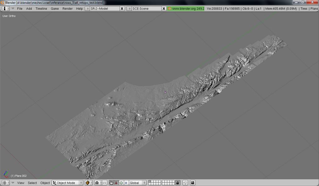
work gently to connect them together
i just connected on so far , i will continue tomorrow
one important this to 64bit users
do the retopo thing on blender 64 ,
blender 32 could not handle the retopo step, in my case of course
have fun
(i think some scaling need to be done . i will do after connecting all parts)
and thanks again , i will post when i have textures
I’m very glad this worked out for you! Looking good there!
I’m planning on another tutorial on applying a good quality satellite image and optimizing the terrain (with normal maps).
i try using the Displace modifier .the GeoTiff results are batter
look previous posts in this thread .
a script to import a DEM or GeoTiff will do very good also
i found some old script ,http://www.siafoo.net/snippet/139 the can IMPORT DEM to blender
well its old , and one of the dependencies are only for Linux .
i found another link ,with some old post in a forum , a guy that wrote a script to import DEM to blender , i lost it , sorry
by the way the image above it without sub-serf , sub-serf make it look very very good
subsurf will modify your mesh and not presere the proper height
so you should not use subsurf caue it’s changing the height by making rounded corner and having more curve which create a distorsion of the original data


 )
)