I have started a part 5 as part 4 was becomeing too large, to easily use.
Part 4 completed itself as decided not to renew my domain web site, expired 4th July.
However in the coming months I might arrange a new domain site with unlimited bandwidth.
My aim has been first and foremost the past ages and bygone times .
I found Blender could easily be used with version 2.79b to create any amount of maritime routes and also scenarios (if required).
I am remaking many of my previous routes as follows…
Starting from the Solway Firth on the borders of Scotland and England and following the coastline down towards Lands End at the Southern Tip of England and might continue around to the Thames Estuary but terrain there is very flat and low lying.
This time I am keeping the routes to approx. below 20km so it will need more routes than before . It took 31 to reach Lands End so maybe will now need up to 50 for same area and much more to follow around the South Coast of England to the Thames Estuary.
None of these details are wishful thinking or conjecture. Previouly I was inlcuding 4 drivable vessels so this time one drivable out of 4 in each route.
Basic texture of merged colours crearted with 3DEM, with one terrain texture.
However decided to use a single grass texture along the rivers and at the coastal harbours to bring out the contours of the terrain.
2 screenshots to help to explain.
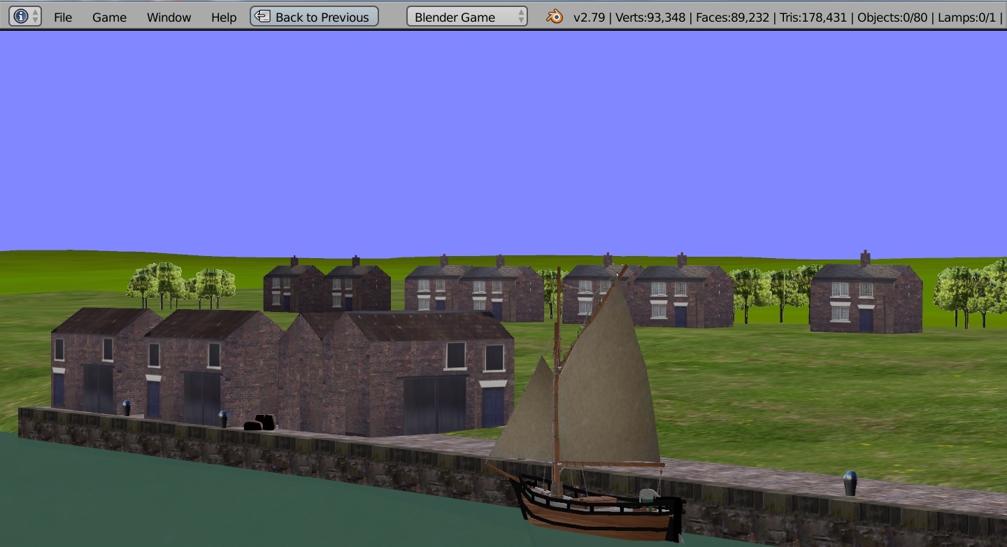
Single merged colour texture. Any colours can be created for the height map using 3DEM. Along the rivers and coastal harbours single real life photo grass texture. Terrain using srtm2/hgt. Also using the Gimp. Harbours and ports with OpenStreetMap as a base map then deleted.
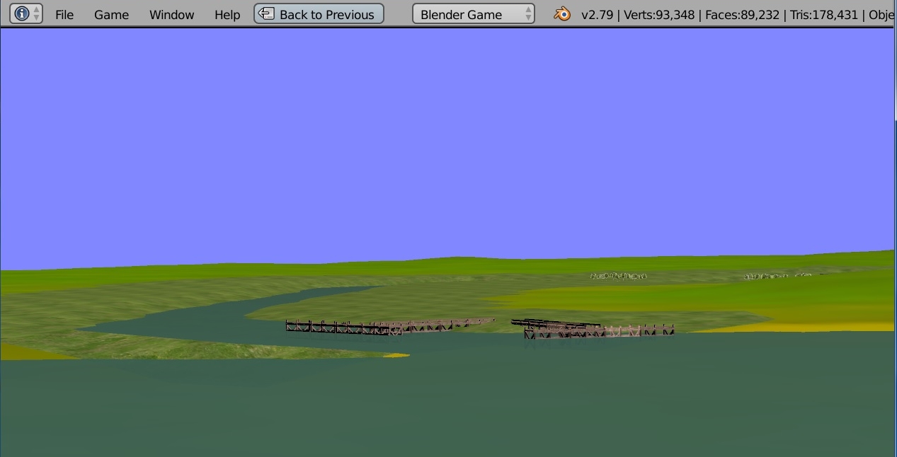
The jetties at the mouth of the river Annan were originally used by the largere vessels and sailing ships, posible by emigrants overses and coastal.
Current online maps show just the footings of these jetties protruding out of the mud and silt.
I am not making scenarios this time round but might make preset routes and one drivable vessel as mentioned.
I have been experimenting and the length of roaming camera reduced to 10,000.
For the larger routes I has it set to 15,000 or 20,000 length meters and 100, I think. I tried 50 but distorts view.
With the roaming camera it is not fixed on any one object. Just guessing really.
Also altered the fixed height to between 5 minimum and 50 max. in logic bricks. 25 max height was too small I think .
I copy and paste the roaming camera from route to route, together with the objects.
Still using windows 7. I don’t know what will work in windows 10.
Microsoft support for 7 ends Jan 2020 I thknk so time to replace 8 year old computer and windows 7 and maybe new domain site.
Thanks Barry
General With 3dEM I could make a greyscale height map perhaps of each route with height and dimensions, and put it on these pages if others want to experiment, let me know. Currently using Blender srtm script.
The area of routes already made, mainly basic, stretches from The Solway Firth, around the coastline to Lands End, routes 1 to 31.
Debating how to continue as one man band and to be honest I have now lost all interest in Blender .
So will think about continuing at a later date perhaps but probably not.
Although think there is more against me returning to making routes again.
Absence of simulation making and so far not seen any to download over two years which seems peculiar …
I know you can always make routes with the previous versions such as 2.79b but in the background is the complex changes to the Blender system which are far to complex for my interests after an initial look at it.
Anything else will probbaly take a backwater by the forum members .
Finally the micro economy has entered the scene which seems to include content and various scripts etc, programs, which perhaps were once free will now require you to puchase them.
So at the present time not really anything more to discuss and to me seems to be a totally different Blender which I have used for many years off and on.
So best for me to call it a day unless Blender changes tack which is unlikely.
Still wondering if any other avenues as regards basic ship simulator routes.
Also the branch of upbge. Routes I make are 20 to approx 40km in size.
Doubtful about 2.79b in the future, even for downloads, as the strength of Blender seems centred on 2.8. Simulations seem to be totally ignored yet can be made as I have proved.
Blender seems to be racing ahead, already 2.81 discussed yet nothing for making simulations on land sea or air, and of course everything I make is free not with a price on each item.
Using 2.8 is out of the question, and have no interest in spending years trying to understand it, for obvious reasons.
Can UPBGE still eventually become part of Blender, still using logic bricks etc and downloaded easily contained in a Blender package? Or is that now a totally lost cause?
Finally I won’t consider using Blender or UPBGE unless it widens it’s field of interest to include large size real life simulations, intereractive scenarios can easily be included, and they can be as simple or as complex as you wish. The few I made were simple, load cargo of barrlels, rescue stranded crewman etc, push vessel back to quay, etc. Complex could be wrecks, tidal, minefields, naval, tidal, etc,
Finally everything must be free and not a price tag on each simulation/object.
So maybe a seperate forum would be required !
If there are any free websites suitable for downloads could you post.
They would need to be suitable for updating and downloadabe of a few maritime routes. 2.79b’
Become tired of paid domain name sites so won’t be renewing my previous domain name contract with ISP.
It would have been useful/ifdeal had a facility been availabale by blender artists for downloading and updating my maritime simulations up to about 25 meg zipped - even for a small fee!.
All my routes and content were free but not for commercial use.
Keeping to 2.79b if I continue.
I have used paid website domain space for a dozen years or so off and on in the past but had enough of them now with their varying details.
B
Landscape of part of The Solway Firth Route. Harbour Annan central, river winds it way down to the Solway Firth - Wood pier at mouth of river. On the opposite bank to left on the Engish side wood pier, 4 drivable vessels (just to keep them in one place).
Have you tried itch.io? You can upload your game/simulation there, upload updates, post about those updates, it’s a really good place for indie development.
Maybe a change of tactics and might reconsider site renewal.
Most of my routes so far have included many miles of empty coastline and to make that interesting I think would require a a different type of maritme simulator than Blender.
What would be possible though is continue with the route making in a differnt way. Fisrt change all the textures to jpg which would reduce 10 or so textures down to maybe 2 mb from 6 meg or so.
Next only use a secton of the route and instead of 20 to 40 km size is will be uo to about 5 km max. At that size i would mainly be centred on docks, harbours, some coastline and possibly even a scenario in each route.
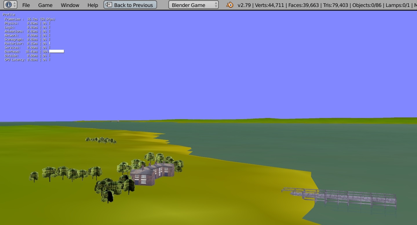
I took a section of the Silloth route which when zipped was 2.93 meg. at 3.5 kM square approx. Screenshots below.
The scenario to rescue crewman from vessel that has run aground is off the image to right. First white dot to right of dock. The dock gates are animated to open from the keyboard. A few more vessels could be added and houses trees, etc and kept up to 5 megabyte and possibly 5 km square approx… The screenshots are just from a quickly made section from Silloth full route so definitely no ‘critique’ (smile). B
9 kilometer route looking across the Solway Firth from where Port Carlisle was built. The harbour of Annan is as before, collect barrels scenario. About 12 textures changed to jpg. Zip size of route 4.6 meg.
This method seems to be the answer. Much of the previous coastline was not required. Frame rates excellect at default 60 vert sync.
Would have to remake rise and fall of water sheet but now will see what happens with ISP. Textures only needs merged colour height map using Gimp and grass perhaps near the harbours and their rivers or small section of coast around harbour.
So far I seem to be flitting from one idea to another, but at the same time I have explored all the realistic alternatives.
As far as I know I should be able to bring back the downloads of maritime routes from a reinstated domain name shortly.
IF somebody could show me how to EASILY make BASIC steam ships, I need not be tied just to the age of sail. Everything I make of course is free and the only restriction is must not be used for commercial use, and use at your own risk, etc. I am using 2.79b to make content and won’t be using 2.8.
2.79b seems to have all I need and still much to explore in it.
What I will do is convert all the textures from png to jpg which should reduce the texture size by about a third. This It is because not importart the artistic side. More to do with harbour and dock operations in a basic way with some scenery objects.
Size of routes can go back up from 5 or ten km. to 20km plus.
Simple interactive scenarios can easily be made within routes.
There are some fine artistic panoramic view made by forum members, but if these were on a larger scale, FREE, interactive, they would then be simulations even if only parly based on realism.
Simulations can include, walking, driving, running, undersea, shipwrecks,transport movement, castles, Snowdon Mountain railway, old trams, etc, etc, if all based on some real life realism. Even pirates if relevant to an area of real llife coast line.
I would be interested as mentioned in steamships of very early 20th Century/. Also any links for making similar ships basic with a couple of 1000 vertices. Using 2.79b Blender.
Just to let you know I have given up on replacement domain name site again with contracts, etc and requested my application for new domain site to be cancelled.
However I won’t be giving up on 2.79b Blender as it seems to have enough functions for creating interactive maritime coastal routes from about 20km or less up to about 40km.
Ships can be be made ‘floating drivable’. Ships can be set on preset courses to run for up to an hour or more. Interactive scenarios can be included in routes of numerous types.
I simply used my own photos for textures and the meshes read directly from the various meshes not rendered.
Terrain is based on satellite data srtm2/hgt and docks based on base map from OpenStreetMap.
As there can’t be any further downloads unless I find an alternative without complex contracts I might still place some screenshots on the forum. Currently useing drivable sloop, sailing-flat, schooner, cutter, and very early paddle-steamer.
I don’t know if it is allowed to make mini maritime routes with scenarios (if required). I had problems packing it into a blend file so trying a small zip file.
If permitted I could place them in the completed routes section. All would be free textures, free objects and free route. The only restriction is use at your risk and not for commercial use.
These mini routes would be interactive.
Could you please advise and if allowed I could make the max size from say 1 to 5 megs. It would add interest to the compleleted routes section and could include a small scenario in each. If allowed my thanks to the Blender Artists management. I have given up with the domain site I had with the contracts, etc.
It downloaded OK.
The roaming camera is home/end and arrow keys.
I think I set the height of roaming camerat o min 5 meters and max at 50
With such a tiny route I only set the view distance to 1000, I think.
The water plane is set To fall and rise to simulate wave swell.
The ideal would be up to about 5 meg. as could include some scenery, using just one drivable ship/boat, also perhaps include a simple interactive scenario in each. rescue crewman, deliver or collect cargo, or whatever.
Also please advise if you want them in the completed routes section as I won;'t need to update and and can just make more. I feel like a change from the large routes and miles of coastline.
Of course discussion is most welcome but they are not made for critique. My own critique is the brightness need reducing to about half.
B
I hope you don’t mind, I’ve added @martinsh water shader and made a couple of changes to your scene. I really don’t think changing brightness is what could make your scene more visually appealing.