Hello. Long time lurker, but this is the first time I’ve ever been brave enough to upload any of my render attempts; mainly because they have usually been awful and also because the critiquing can be quite brutal (though never unfair). However, I’ve decided I’m never going to improve if I don’t share things with people who know what they are talking about!
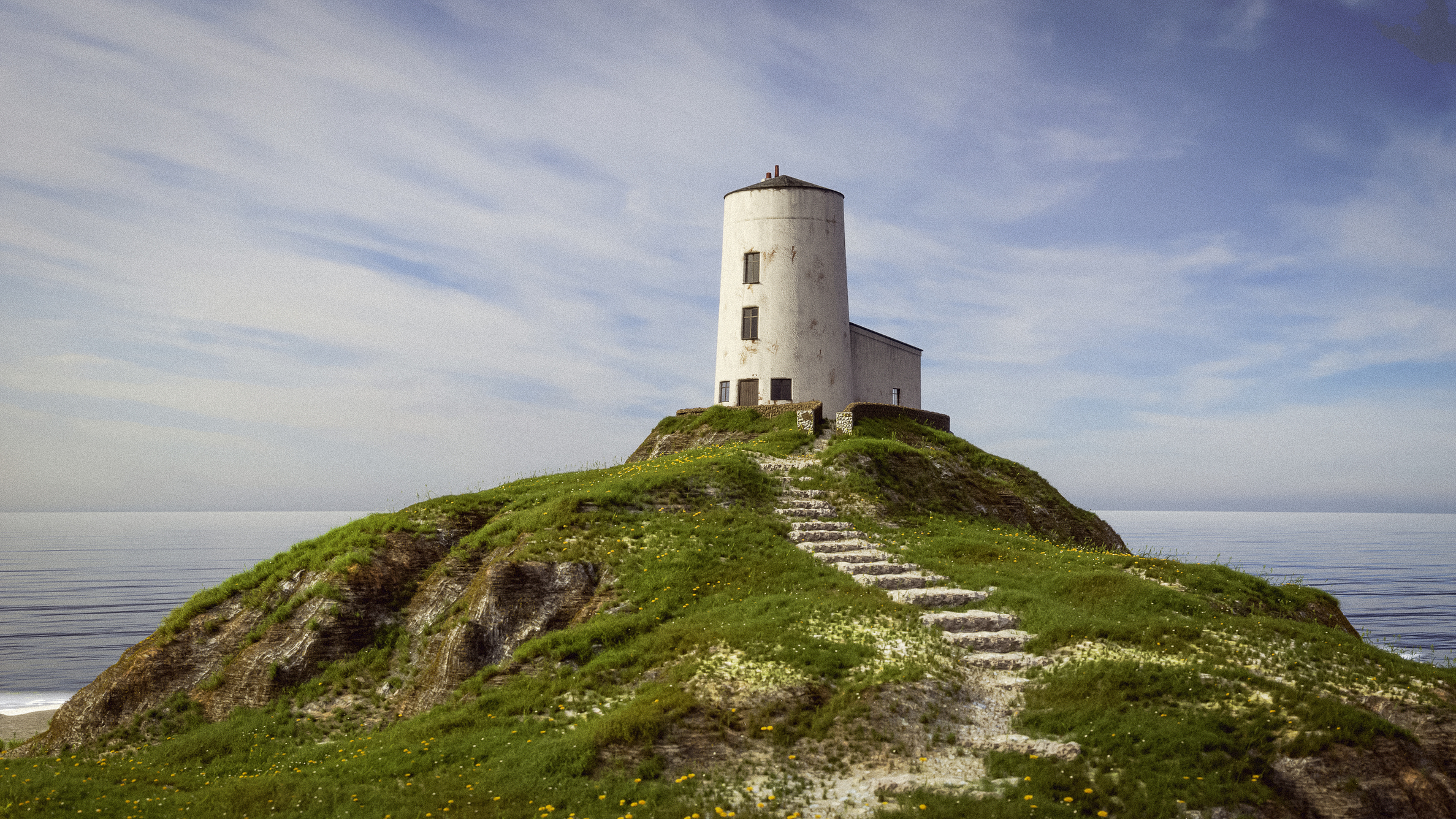
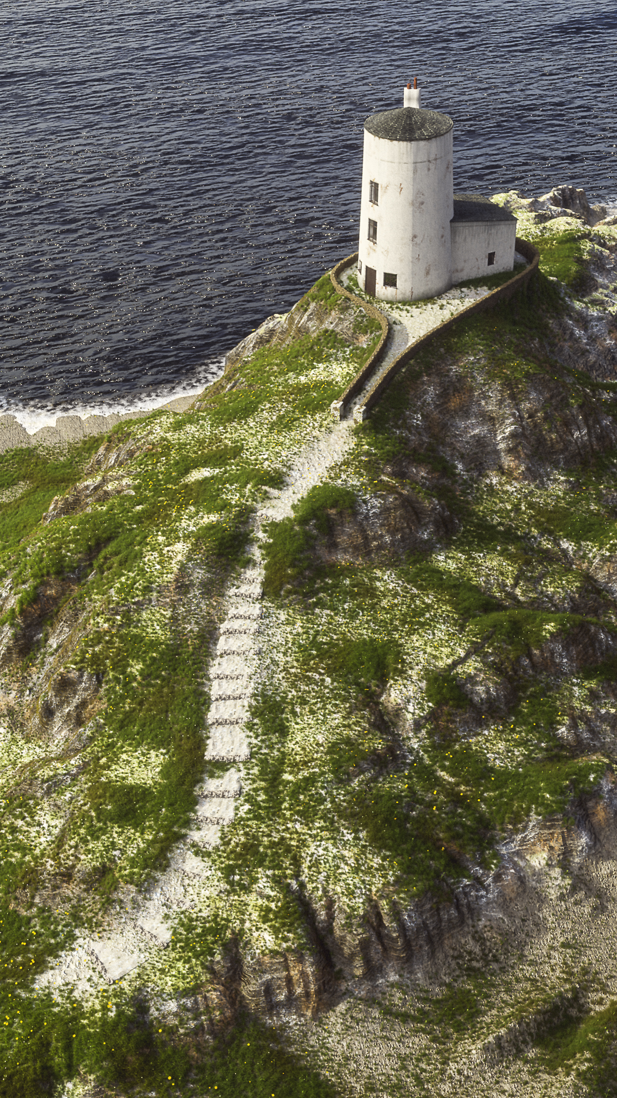
This is a lighthouse in Wales. I’ve never been, but seen many photos of it on Flickr and thought it was simple enough for my ‘skills’. The base topography is taken from 50cm LIDAR data from the Welsh government, brought into QGIS to merge and crop. I then took this into a new piece of software called Gaea (by Quadspinner) to smooth out the LIDAR artefacts and add more detail (using the erosion and sculpting tools). Then brought into Blender and displaced (using the modifier not microdisplacement).
‘Modelled’ the lighthouse and wall, did some sculpting of the rocks to add more detail. Grass and flowers are from Graswald (obvs), HDRI from HDRIHaven, texturing from textures.com (all free low res versions…). Some compositing done in Blender and PS (including judicious cropping). I think it was about 500 samples in cycles (2.79… can’t get my head around 2.8 yet), but rendered at quite low resolution as I’m impatient.
I know there are some glaring issues, but I’d be grateful for any advice on how to make things better and to improve my techniques and understanding. Also, if I’ve made any errors of uploading etiquette then let me know too!
Well I gotta tell you, your work looks incredible! And I can’t critique it, as it’s far beyond my skill level anyway! The composition is great the details are great, so all around great job!
Terrific work. You’ve been lurking too long, your work clearly can benefit and be enjoyable for others.
The only flaw that stands out to me as noticeably CGI is the water - it seems like the scale of the ripples is off compared to the lighthouse. Also, where the water meets the horizon it looks too crisp. I don’t know how to fix it, but perhaps extend the plane of water back, ensure that the render distance is great enough, and ensure that the camera doesn’t have infinite depth of field (which you already set, at least in the third shot). That may make the horizon a bit blurrier and less distinct.
But really - I think this is very realistic and good work. At first I thought one of them may have been a sample photo you were copying.
Looks great! I would play a little bit with colors, make the shadows and the overall look less grayish, most probably using color balance. But that’s just how I see it. Otherwise, thumbs up bro
Is there any chance you could give a fully detailed account of how and where you got the LIDAR maps and imported them to get the whole thing up and running inside Blender?
I think you really did a good job! That thumbnail of the top row triggered me because the shot is simply beautiful. The image toning is also nice.
I see some minor fire flies, which i dont understand and where they would come from. Perhaps some intersecting meshes. Yet im not sure Cycles has this issue. I use a different engine which does have this issue some times.
PS you did quite a lot of work on converting that data i think. I tried QGIS and it can be a bit finicky to work with. The island, i think its an island looks really nice. You used dof quite well to hide the low res textures.
@rombout@Nitram_2000@Karlb@Aotuhm@robwu Many thanks for the positive feedback and advice. It is very much appreciated (sorry for the tardy response and appearance of ignorance, have been AFK for a while and having IT issues which have now been resolved!).
I’m not really very good at explaining how I’ve done things, as its all a bit of trial and error at the moment. Perhaps when I get more skilled, I could come back.
The welsh LIDAR data is available from: WELSH LIDAR
Similar data for England is available from: EA LIDAR
Just for fun, here is the final render I did. It looks OK, apart from being a bit bare in places. Also how the sea interacts with the beach looks really bad and unrealistic. Any advice on how I could improve that would be appreciated!!
I had found those links, very handy for you guy that such data is available.
Making the beach look good, where the ocean touches land, is very hard to make look good. Some go as far as making wet maps for the parts where water touches sand. If you want to see something amazing. Look up the short from Disney calles “Piper”. Try to find a making of, you be blown away by that!