Large basic maritime Routes work in progress.

I have been about a dozen years with Blender and beginning to realise perhaps there might be an alternative to the continual changing formats of Blender which might be more suitable for realism, ships and simplicity.

Had a look at the latest version 3 of godot but no idea what size routes could be made, what type, also seems complex so looks as If I am in for the long haul with Blender. Also I think upbge would need to be incorporated into blender for me to use it…in case I make the routes downloadable again and reinstate my domain website. B

So will carry on until/if the Blender Game Engine begins to unravel and same with the script. At that point I will continue from the last version of the Game Engine and script that functions normally for making these larger maritime routes. So will start collecting each version of Blender until then. So far remade 10 basic routes 20 to 25 km approx. Isle of Man 43km from Solway Firth and around past Morecambe Bay . After I build a good stock up then start remaking the rivers, etc. As mentioned copy and paste works fine so one roaming camera and one sea made, then pasted into the other nine routes.
B

So carrying on. I think there could be a misunderstanding with the details of a sailing simulator or maritime simulator. I do not think it would be possible in Blender to create a commercial type of complex simulator with different dtvable ships with varying performances and much complexity.

What I have been trying to do over a few years is create a maritime environment with enough distance on a route so that ships can move from port to port. Ships can be made to look quite realistic and I made three types schooner, sloop and sailing flat, barge with sail. The difference is they are solid and era I try to set is up to about 1815. . But using the timeline and the logic bricks I had ships manoevering from dock to dock in 1800 docks of Liverpool. stopping at a quays for 5 or 10 minutes then moving off say upriver for about 10 miles to Ellesmere Port Barge Dock.

Same with the river Ribble and Douglas with trade moving from say Lytham along the Ribble to a quay at Tarleton. With the river Conwy there were the slate quays at Deganwy and upriver Trefriw quays and Watermill at Trefriw. I made the river Ribble Tidal. I used to have a small boat 21 ft on the river Douglas about 50 years back now so I know some of the areas.

The point is even with the limitation of Blender Game Engine, maritime routes can be made based on real life terrain. It is more about simplicity with realism so it does not drain the frame rates. Should somebody somewhere be interested all that you need initially is to make the terrain. If removing the seabed maybe up to about 30 km. With the seabed keeping the option for deep water hannels, etc, maybe about 20 to 25km. Ship movements seem to work OK using the timeline over say a an hour or so at about 5 to 10 miles and hour for sailing ships and barges, etc, over the route distance mentioned. No problems with that so far. Even if the script no longer worked Using 3DEM the srtm2/dem map can be saved as greyscale and will generate the terrain with the displace function in Blender. Not as accurate but still fairly realistic.

Barry

P.S. In these routes you could have one drivable ship and numerous scenarios can be made with basic functionS, such as collecting a cargo of barrels, pushing ships, launching ships, etc. Probably an endless variety could be created. Invisible walls are useful with deep water channels.

To complete the short tutorial a mention of 3DEM. About 15 years old and no longer supported. However still seems to work OK and can do quite a lot. Aerial views can also be made as the map moves across the screen. Once you download the srtm2 satellite data and extract the .hgt file it open the height maps and shows the terrain exactly as it is in 3D. It is available from a few sites still and a quick search should find it to download. Any part of the dem map can be made. Heights can be coloured in any colours which merge one into another.

The texture can be exported to use an overlay when the terrain mesh is made. The size, height and coordinates can be obtained from the DEM map.

The co-ordinates are all that is required together with the srtm2/.hgt fle and read by the script in Blender which creates the mesh. If the script becomes unavailable you can still export as a grey scale map and route generated with the displace function. IF REQUESTED I can expand the details how to use it. There are instructions with it.

Barry

I mentioned that you can make routes of any part of the world. Maybe most parts might be more accurate. It only takes a few minutes to obtain the area required. The world is split up into areas and there is Eurasia, Usa, South America, Australia etc.

I am using Eurasia for the uk but had a quick look at the Caribbean and downloaded a section.
IF you open it with 3DEM. Texture it any which way in 3DEM and save texture as tga. also you can export the route as USGS ASCII dem.

There are a few ways to do things. Either obtain the the co-ordinates using open street map or 3DEM, then download the relevant srtm2 section. open and drag out the hgt file and use the script for either method.

There is a quick start guide and a map of the world you could use as a help. However all very simple to use and to make a full basic terrain mesh only takes me say half an hour. Then copy and paste water and roaming camera into each route.
Same with ships/boats when made.

B

Tried the greyscale method to remind myself as good few years since used. Flat plane subdivideD 8 times I think makes about 66,000 vertices. You can use function… images as planes as size not important and it is 1 meter plane with 66000 vertices with the greyscale texture already on. . When mesh generated set the max height and the size of area in Blender. This test was 20,250 meters square. height 884 meters. If you make a second colour texture in 3dem you can then replace the greyscale with colour terrain texture and make it same name. Later you could use photographic textures, etc.

It might be possible to make a range oF greyscale routes of various part of the world and put images online and forum menbers could then generate their own routes using the displace function. So a library of routes? All you then need to do is place the base and water area of route on zero x line. I used to have several the greyscale maps on my domain site for download.

B.

i have used grayscale tif height map data and i think it works good. the important thing is to remember that they are 16bit high depth, and only a few image editors support it.

krita is the one i use for this. but i try to avoid editing, and just uv map it.

setting the height texture as a bump map is a great way to get details with a low poly terrain.


Thanks for the info and useful to refer to.
At present the srtm2 data works fine just drag hgt file out of zip. Then Blender…/File/Import/Srtm.
You only need the co-ordinates. Use OpenStreetMap or download 3DEM about 4 meg. Still works but 15 years old or so?
However it depends on the Blender scriipt remaining available and that is were the alternative info might come in useful at a later date.

Never heard of Krita but will look into that one.

See bottom paragraph and link to page. River Mersey my area hgt files N53W003 - N53W004. USA and most of the world files can be downloaded.

https://www2.jpl.nasa.gov/srtm/

…B

Obviously there is little or no interest on these forums as regards making maritime routes based on real life satellite data… and with scenarios if you wish.
However that is up to others and should there be some pernanent interest in making real life routes at about 20km square minimum I would consider reinstating my domain name site. However ‘permanent interest’ would be the keywords.

Previously I had upto about about half a dozen maritme routes avilable for download. It is essential that routes are not stand alone, i.e they require Blender to be installed. The zipped file size is essential and my previous routes were about around 10meg more or less as depends what is added. To make routes available for download means that stand along routes would not be possible due to file size… and domain sites arn’t free. So it’s a case of the future progress of the Blender Game Engine and so far with people locked into making only Small games/art not impressed…at least with the possibility of making downloads available again for others. Plus the fact the Game Engine chnages might be ‘one change to many for my interests’.

So far remade 14 maritime route at about 20km and when the stock build up I will beigin to make the rivers. However this time round will make a good stock of the basics routes at about 25km square at about 100,000 vertices. Solway Firth around to the Dee Estuary.

Please not these ar the details so no interest in reading non relevant replies , critique, etc.

B

The question is would it be worth reinstating my domain website to make BASIC downloads available of maritime routes.
It would be essential to be embedded routes only as the file size of stand alone would be imposssibe. Previously the route size was about 5 to 15 meg zipped. Large zip size routes would not be feasible due to cost.

Again routes are NOT for criticism as would depend how you alter them. So more for me to criticise YOUR EFFORTS (joking).
Anyway it would need half a dozen people PERMANENTLY interested in the maritime world as simulations. Made with Blender Game Engine. Perhaps making YOUR own routes as well. Era I make is up to about 1815 age of sail but you could make any era and most parts of the wolrd with satellite data. So would need discusion and possible info of your RELEVANT route making.

The other spanner in the works is the uncertainty of the future game engine as the person downloading would need the relevant Blender installed. So far all works well up to 2.79. However what next?..no game engine? altered game engine but no longer usable for routes at 20 to 25 km (no problems with that at present). Stand alone would be useless due file size and domain site cost?

I think there is too much uncertainty after reading the various interests and the for and against comments.
Future forecast for the game engines seems ‘cloudy’ (Tried the sky dome once connected to ship/boat.)

There must be a wealth of knowledge about that could be channeled into making larger routes up to about 25km.
Not conjecture as I have made many including up to 45 km but that size can be tricky so max about 25km. Frame rate still 60 vert sync. Vertices can always be thinned out or distant areas not shown as ship routes not just terrain land routes. If you made you own maritime routes, you could always advise me about the method YOU used with full details.
There is no interest in me using other forums or game engines as Blender seems the best option. Most maritime simulators are commercial and have used most of them over the years. Only interested in open source.

B

As regards the interest by others iin maritime simulations on these forums are nil. My interests are only maritime as portrayed in the various marittime routes I used to have available for downpload. Should Blender decide it wants to be a serious Game Engine it needs some interest to be made as regarding real life simulations. They don’t have to be complex as mine were free for download and no commercial interest.

One of my first observations was a moderator who said he could’nt be bothered reading my short post as there were no images. A ridiculous commnent, when downloads for routes that could take hundreds of hours to make and many detailed pages with screenshots, downloads, route descriprions and links were a few mouse clicks away. Also as my interests are the past ages and bygone time the era I try to set is the age of sail. If that is the general attitude of modetators it cetainly doesn’t help the serious side of Blender in my opinion.

This I think this set the tone for some of the critique comments and and other comments when making simulations. Simulations and routes are NOT small games but about real life, based on real terrain whch can be set in any era. This is what I thought originally would be what these forums were about. In addition of cause to small games and art works which of cause is all part of Blender. So I was wrong.

So methinks to reinstate my domain website with regards using Blender to make routes available for others would be a waste of my time and to advise people what is available on this forum not wortwhile. Routes have been about 20 to 25 km in size and 6 years old nividia card and computer and still frame rates are at the default vert sync. of 60.

However as the past ages and bygone times I consider are as important as the so called ‘future’ I am considering reinstating my domain website with possibly some basic dowloadable routes. If no routes there would be probably n numerous mini screenshots as regards the past ages and Blender content. I will probbaly not be posting on these forums again unless of course maybe seperate sections for real life simulations (which is unlikely), and interesting discussion around serious route making in the Blender Game Engine. If the future format of it allows integrated game engine and not stand alone due to zipped file size.

Finally I amd unlikely to post further on these forums and should you wish to contact me I will be back on the UKTrainSim simulator forums under the Shipsim or Blender forum sections, under name precar (before the car age), which I have posted on for several years and would see your post as I usually read the Open Rail forum etc. So if seriously interested you can find me there. B.

http://forums.uktrainsim.com/index.php

.

Should anybody use my tutorial on this thread I came across an interesting thread for people interested in Blender and Maritime.

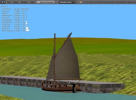
So I appear to be the only one on these forums at the present time making maritime routes at about 25 km square. Rather than abandon the project the route and content making will continue. So should you wish there is no reason not to extend your interests into ship and route making in Blender, merchant shipping or naval or submarines undersea…

As I had previously deleted all my routes I have started afresh. The ‘basic routes’ are are already 16 remade, stretching around the UK coastline, starting from the Solway Firth, the borders of Scotland and now following along the coastline. The next will be the river Conway and the Conway Valley. Basic means terrain textured with merged plain height colours made with 3DEM. Roaming camera, semi-transparent textured water sheet, using copy and paste from route to route. When the routes stock builds up I will start slowly making the river systems in addition to new routes and texturing along the rivers with grass photo textures. The distant terrain can be left with the 512 px of merged plain height colours generated with 3DEM. Only the coastline and river systems matter and canal systems…

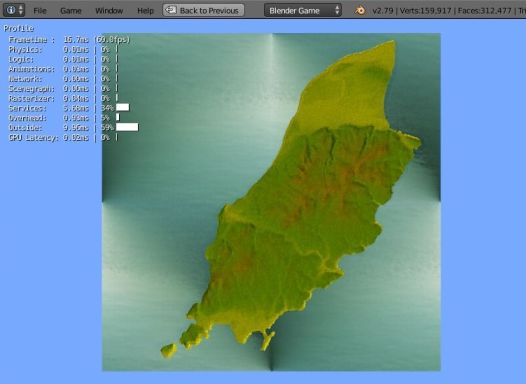
Without LOD, frame rates for vert sync. still at default 60. Vertices about 80,000 to 130,000 depending on route size about 25km and 43 km for full Isle of Man. Vertices can always be thinned with limited dissolve or seabed completely removed. At present I will keep them to perhaps make deep water channels at a later date.

I have also fixed roaming camera heights now which makes it more realistic as the view is not about travelling over land but coastal and rivers only. So basic routes now made are 16. Today route 17 will remake the Conway river and valley followed by the Menai Straits area. and Anglesey. A full Anglesey will need 45 km or or more, but might try it again at that size and remove the seabed perhaps. Could make it in two halfs but prefer the whole island similar to the way I made the Isle of Man.

Considering reinstating my domain website as mentioned. If UPBGE becomes seperatte from Blender with installer I would change to that if it became permanent and larger terrain meshes could still be made. Blender is about making things and I make maritime route simulations, at the present time era about up to 1815 !

If posible I would try and make routes available for download if I reinstate my domain site, but some method woudld need to be used to keep the actual route zip size 10 to 20 megs., if the embedded option was not available. At least people would need Blender or an UPBGE version. If not possible t would just be screenshots and descriptions on my site written around Blender content I make as before. Either way it depends on others who are updating Blender.

If the decision is to remove the game engine well tough luck unfortunately … for others, as I will keep the last workable version for route and content making. As mentioned it is also about the past ages and bygone times. Finally I have NO interest in reading any critiques of any sort from others…relevant discussion of course is most welcome regarding making large simulations, especially maritime related and over 20 km size !

Thanks…

Barry

As these threads are read by people not on the forum I will continue with the prelimary route descriptions.
So all previous routes were deleted a little while back and as I am considering re-instating my domain name forum, about the past ages and bygone times, illustrated by using Blender with coastal route making and canals up to c1815 (maybe).

So now at route 19 basic routes Solway Firth to Menai Straits and Anglesey. From Anglesey the next will be following around the Lleyn Peninsula, North Wales and heading towards Port Merrion, and Harlech…

I made two versions of the Menai Srtraits. The large one is a very large size for Blender at 45 km and includes the full island of Anglesey. By removing the seabed part of the mesh but leavinga a border of mesh a few miles wide at minus 7 meters around he whole island I reduced the vertices count from about 450,000 vertices down to 245,000. It could be reduced a lot further using limited dissolve of the terrain. However with any forthcoming changes it might not load so keeping that as a mesh. Using a middle range Nvidia card about 6 or 7 years old and default vert.sync still at 60 fps. A water sheet at zero height cover the whole area but I will make another flat sheet of 4 vertices to replace the removed seabed at minus 7 meters. Not necessary but makes it look better without a big hole in the seabed.

So before anybody reading this nods off asleep I will have a small noggin of rum (second thoughts a sweet sherry).
As mentioned there are a multitude of scenarios in the maritime world that could be created for the skilled creative minds of the forum menbers. Ahem.

Horse drawn barges along the canals for one. I have used them before but in Trainz train simulator. The horse made by somebody else and coupled to the barge with offset coupling as an engine. A ‘train’ could be made any shape and could run on 'invisible ’ track. Trainz eventually became too complex for me to include ships and barges .

Barry.

Blender Artists forums I consider unsuitable for the discussion of simulations, especially maritime.
You can contact me on the UKTS . UKtrain simulator forums, either Blender or ship simultor section ‘precar’. However my thanks to the few people who did offer constructive relevant help. It is not worthwhile, and a waste of my time for me to post further here.

http://www.uktrainsim.com/

B

I am starting again with the maritime/canal route making and also will be reinstatng my domain site as altering the ISP contract. Once that is sorted I will start writing up decscriptions around the content/maritime routes I make. I concentrate on the past ages and bygone time. All routes will be basic to start with and and also the texturing using 3dem. Routes about 25 km to 45 km square. All will be simulations not games, and all will start with a roaming camera and possible nothing else except the terrain based on satellite data srtm2/hgt. Simulation can never be completed as there is always something to add/alteramend or retexture. If any downloads are made they are not for commercial use but you can add or alter any you want.

Details on my site will be a mix of the past ages and bygone coastal times and some Blender details.

The main details will be on my site so probably just single line description with updated date on the forum.
As I have no idea what will happen to the Game Engine I will start again working around the UK coastline.

Also to avoid any possible ‘friction’ if you have any queries post maybe on this forum and same for me and I will post any problems I have and post here (plenty of them) ?..or wherever.

Just to add although the routes will all start as version 1 basic as the versions and routes progress I might add scenearios for collecting cargoes etc. The site will have screenshots, descriptions. Downloads if available will depend on bandwidth and what I have made.

Finally if no interest from members of the ‘blender artists’ it does not matter as not important now, as my previous site was also about the coastal past ages and bygone times and the same for the new one eventually, so seemed well read from the Google/Bing searches and site stats.

Thanks

Barry

P.S. I think a better method would be to list these in finished games/routes forum. As mentioned Simulations of this type can never by ‘finished’ as no way to knowimg if finished. Based on real life of the past ages so. Better method would be to use a single line description in finished/games. They will start from version 1 then if/when the route is altered it becomes version 2 and so on.

Found my thread and as simulations can never be finished I will carry on posting here.
I was going to post on the finished forum but I have no idea if finished or if there will be many updates.
Also unsure if I will be able to make any availble for download but should know in a week or so.
Starting from the beginning again working my way around the coastal UK with 25 km routes.

Full isle of Man made but 44 km so won’t bother to include it.
Highest mountain in Wales Made but only adding a roaming camera to that one and as inland won’t inlcude it.

So Solway Firth 25km…opened up about 7 rivers which took a good few hours, roaming camera and drivable sailing flat so era early 19th C (maybe).
Added quay at Annan but need to add warehouses, barrels, criss-cross trees, houses and bollards.
Also need to add quays at river entrance from which the large sailing ships left with emigrants.
I added photo grass along the river banks to show the depth.
The inland areas I will leave with plain coloured heights. Gimp two different tyes of noise and bump map.
Sea not yet animated. That about it as just as an outline/example.

Forgot to to give the sea collision propeties but when added the drivable boat bumps gently against the quayside instead of bumping along.
Whether I add scenarios eventually depends on others if there is any interest. Bit fuzzty as quarter size and rigging only part visible.

B

Blender Game Engine suits me fine.
Another example of 43 km full Isle of Man.
I have tried it previously with rocky texture around the coastline.
drivable sailing ship etc. You could add quays and some trees.
Shows the default vert.sync at 60 fps with 7 year old nividia card. windows 7.
The difficult part was making it as sticky, but seems to run OK using roaming camera.
Just another example overhead view.
I deleted most of the seabed except a margin set to minus 9 meters,
B

I mentioned that you can make every simulation to include game by creating a scenario.
Ship touches rocks the ship disappears. However nice and simple to start with to remind myself how to make them.
So collecting cargo at Annan quay. I sippose any amount of scenarios can be craeted.
Created some barrels and crates so in this one ship collects barrels using offset collision box on a few barrels.
To make it more difficult you could have floating logs or boat blocking course or whatever.
A crane could be animated to place crates in ships hold (not made that).


B

Just to mention originally I used the dynamic setting for drivable ships but the ship had a habit of flying into the air or rebounding of quaysides.

To make floating I offset the collison box so the base of the collision box is at waterline level. Sea sheet also has collision box. Anyway I found that changing to rigid body made all the difference as the ships now can bump gently against the quaysides, ascend locks, etc, even when the lock walls are close together. I will just keep everything simple.

I probably will just use ships on preset tracks and not drivable, as I don’t really need them drivable, same with scenarios…unless requested, and if I can make them downloadable. I am more interested in rivers and estuaries of coastal UK.

To make tidal if I wish, flat water sheet 4 vertices at 25km. Using 12th rule. 1 hour tide rise one twelth height of 9 meters, 2nd at 2 twelths, 3rd at 3 twelths, 4th at 3 twelth, 5th at 2 twelths, 6th hour to flat calm at 1 twelth height. I think the easiest way though is set the water sheet to rise and fall a meter to simulate wave swell, boat rises and falls with it, (for now anyway).

Regards optimisation will only try and use if vert. sync drops below default 60 but hasn’t so far as prefer to build up stock of routes timewise. Same with seabed only removed on Isle of Man 44km size route otherwise too difficult to make. but runs OK,
With the 25km routes I will leave the seabed intact in case i need it to create sandbanks, etc.

B

P.S. Must make a few small barrels for the rum. (smile)