Funnily enough I’ve done this too, but my playing around with the idea was for Railroad Tycoon 3. It can be made to work in that game but, due to the game coding being targeted towards rail, there are limits on how useful it is. Still, it was a bit of fun.
Anyway, just make what you enjoy making and using, and don’t worry about what other people think of it.
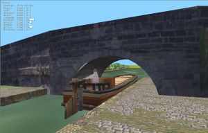
The best part was using the railway tunnels as canal tunnels. Must admit though as it was a mixture of trains and shipping along Liverpool docks. Some members got a bit annoyed when their trains were underwater with just the smoke from the funnel visible above water.
In Blender it took me a long time to make ships drivable as first I ran them on the seabed with water at waterline. Then making sea and seabed with collision properties they were drivable ond surface by offsetting collision box. It wasn’t until rigid body became available that finally made them more realistic without flying off into space when near quay or in confined space when using ‘dynamic’ .
B
The ships I made wouldn’t fit through the rail tunnels. They had to be big enough to hide an entire consist inside them, so ended up being about 500 feet LOA to scale. They wouldn’t even fit under the default bridges on most terrain. But in that game they ran at normal levels without drowning the trains, which was a good thing.
off topic. Open Rails is open source trains simulator.
There are 2 free routes to download which are free standing to download/
Might be of interest but after 7 years still working on program. http://www.openrails.org/download/content/
Just to confirm that I probably won’t be using this site further unless it ‘settles down’.
I have never known a site so complex (for me) and have posted on several different forums over many years. KIS principle certainly doesn’t seem to wotk here. Keep it Simple. But the majority of others users possibly differ in opinion?
I will use 2.78/9 for routes and content making for now and see what happens with UPBGE and Ketsji. B
Trying to work out the best method to continue and regarding a new domain site and continuing to post here .
How long do the back versions stay downloadable i.e 2.78/2.79?
If I made routes available for download again as embedded and not stand alone Tthen if I made a link to the appropraite Blender download page the workable 2.78 or 2.79 should be available for several years for people to download?
The routes themselves when zipped would be about 7 to 20 meg approx I think maybe more. I try and write the desciption around the route based on an era around 1800 - 1815 approx similar to what I have shown on this thread, Should there be any interest I could always include scenarios in a few routes…as that all depends on interest/request from others…if any.
When the position regarding upbge/ketsji becomes more clear then might be able to change to that.
Makes it more interesting when downloads are available as I can update/change them whenever.
To moderators please don’t move this post if possible as might be considered off topic… but it is very relevant to trying making these routes available for download as I have done previously for a few years.
So sail on regardles, keep bailing out the water. (smile)
35 basic routes made.
Remade the saiing flat as shown in the thread.
Next on the agenda remake schooner and sloop.
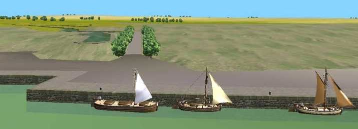
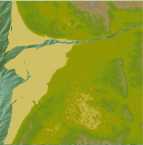
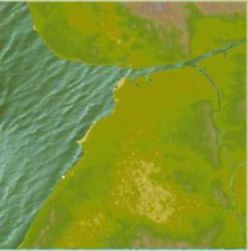
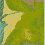
Then they can be used as either drivable or AI using time-line on preset routes. Image shows position of start of Leeds to Liverpool canal c1800
The barges on the canals of the 19th and early 20th century were mainly horse drawn pulled along the many 100s of miles is the UK canals by horses on the towpath.
Making animated horse drawn barges with the horse linked to the barge is far beyond by limited skills
It worked in Trainz train simulator by offsetting the couplings making then horse or barge the engine on invisible track…but that was years ago.
My barges I think will only be sailing flats. The masts (in real life) would be lowered if they have to pass under bridges on the river systems.
Have you thought of trying to incorporate some of the actual sailing skills into a route? Things like shooting a bridge at full ebb tibe, or kedging up a narrow channel? Stuff that was everyday skills during this period, and which might add more interest? It may just be me, but It seems like that could be more interesting than picking up barrels.
I have thought about it and would be very pleased to see what others could do. But my skills are limited and ‘age limited’. The whole world can be explored.
I made tides in one route by raisng the water sheet over a 6 hour tidal rise (starting at any one of the 6 hours).
Boats then have to rise with it and using rigid body or they might fly off into space.
Tidal rise (should anybodywish to try it it) over 6 hours using the twelth rule.one twelth of 9 meters (liverpool high tide height) in first hour 2 twelths in second hour, 3 twelths in 3rd and 4th hours, 5th hour slows down to 2 twelths and 6th hour 1 twelth to a still high tide (slack high water). I deleted all my previous routes a little while back so starting afresh Solway Firth Borders of Scotland around to Borders of Wales at present at 36 ‘basic’ srtm2 routes. Will contiue to Cornwal and Lands End.
I think trying to recreate the harbours of c1800 is enough for me and making sailing ships. Solway Firth route 01 has the several rivers opened up and Annan with the small scenario.
Picking up barrels just an example as the near function can be set to open bridges, etc. Visible/Invisible load and unload people, barrels, cargoes . Cranes can used invisible when cargo put into hold or whatever. Ship launches I have also tried as an animation with time-line .
I think I managed to sort out new domain website after a month or so of problems for coastal sailing ships basic although could set any era. Only problem then I have forgotten how to set up filezilla with host name etc, There is another one winSCP but looks complicated. B
I haven’t used Filezilla for several years now, but IIRC you just enter the hostname in an input box. As long as you have the right hostname it should work.
Edit: Are you running into trouble with the port number? I think the standard port number for FTP connections is 21.
my google drive is still up for grabs if you want to store your resources there. all you need is to create an account with google and i can give you full access to a folder on my drive.
if you are concerned with privacy, just use a private browsing window when you login to upload files. that way google cant track you after you close that window.
Thanks Daedalus, few years off 4 score and I think technology is moving faster than ai can keep up with it. Kind of you of you to offer again but just used to using thw ISP over many years. I used to have about half a dozen routes on it for download, mainly basic land and water, but ended up deleting all of it as getting bored with it. (wasn’t very good anyway).
If it get i set up OK I can stick any relevant links on it if any use to you.
I don’t know if greyscale height maps are of any use of any of the routes made. I haven’t used that method for years. Probably of no use, just an idea. You wii need to alter the file type? removed the images as I might need to reduce size.
I am still using 3DEM to make basic colours but the blender script generateds terrain. Using osm for co-ordinates for the script.
3DEM can still be downloaded for srtm2 data.
I make the basic colour map with it or set it for greyscale.
Not required though for the terrain just the blender script and hgt files (srtm2) needed http://freegeographytools.com/category/3dem
bit tricky downloading it but click downloads if you want to try it. I am using windows 7 still. Don’t know if it will work in windows 10.
Shadows set to zero.