P.S,
I have put some details back onto my site.
At present just the index page available at present.
When I sort the tidal rise out and make some more content I will probably start making some basid tidal routes available for download. Might make half a tidal rise of 3 hours as fastest rate of rise then. No need to spend 3 hours. Maybe half an hour to an hour of 3 hours. B.
Started the new routes idea and basic solway online just with drivable boat, quay and 2 hour tidal rise of 2 and quarter metres. I might make the tidal rise over 3 hours of up to 4 and half meters.
Of course you could just explore for half an hour or so. It needs realism and hour number 4 out of 6 will have the fastest rate for the tidal rise. Refer to my site for further details.
Future routes if available will be 15 to 20km including mainly a single harbour or 2 at most following around the coastline but centred on the harbour only plus the tidal rise.
Link to site at side of posts
B
Making endless harbours I think is also a no go project on hese forums. B
So back to original idea 50km routes, These will start form Isle of Man over to Solway Firth then down around the coastline.
I will give further deails when I start his system off. Also ‘critique’ definitely NOT applicable. All routes will start from BASIC… terrain and texture, sea made, single drivable floating sailing-flat, water sheet possible animated to rise and fall a meter to simulate wave swell. Probably nothing else to begin with. Eventually some will have small updates. I B
Daedalus I posted on your Google Drive thread.
The Isle of Man BASIC route is online. I will have up to 5 online maximum in rotation INCLUDING
If any parts not working post details. Discussion is helpful !
NO 'critique required.
Downloads might be cancelled at some tme.
01 Isle of Man - basic
02 Solway Firth 47km mainly Annan and scenario collect cargo.
03 Lake District - basic
04 Morecambe Bay - basic
Routes rotated after no 5.
Updated 19 Oct 2018
Any further downloads made available for download are now being rotated with max. of 5 on line at any one time.
At the same that finishes my posts on these forums…except of course in reply to relevant discussion or to answer relevant queries !!
Maritime Routes
Rather than juggling routes if you want a route to be made downloadable see below.
If you would like me to make downloadable a route please mention on the current thread.
When/if it reaches five downloadable routes I will then start to remove one…to be replaced with your chosenf route to download.
Nearly all of the routes will start as basic and based on srtm2 satellite data. The routes will probably be the larger size of 40 to 50km approx.
They will follow around the UK coastline from the Solway Firth. This method will save me a lot of time wasted in checking and zipping up routes etc ready to upload.
B
check this out - I was able to fake pretty realistic water using the same mesh as my terrain
the shallows are faked 
I use the vertex color
if it’s blue channel is over .5 -> I mix in the water / vertex color + cos driven perlin/musgrave noise
(we can use the musgrave node from cycles in the GLSL node editor)
Thanks for your post. My problem is I only know how to use Blender in a very ‘basic’ way. over 15 years using it I think. My age now is also limiting factor, so most of the technicalities are beyond me.
Regrding sea I just use natural texures from photos Liverpool dock water , or canal water even and adjust it with the Gimp. The route size is now 40 to 50 km and animated water rise and fall sheet covers the lot at 4 vertices or can be made tidal with the timeline.
With actual waves the very few professional ship simulators that still remain I think move the waves with the ship which merges into still photo tetxure water in the distance.
Barry
1 Like
Having explored all the options for file terrain file size up to 50km I keep altering the format relating to Blender and mthod of working. As far as I can see Blender is more than capable for making maritime routes.
50 km size can be made and the decimate function clicked 3 times reduces the vertices down to abiout one eighth of the starting vertices count. I tried just harbours but that also can get boring.
So methinks up to 25km might be about the best reducing the 124,000 vertices count down to 62,000 with the dcimate function. Easy then to subdivide selected areas to work on and maybe change quads to tris for a finer size terrain mesh.
If I continue I think I would need to start a new thread for downloadable 25 km routes. and for downloads I would only put on my site what people request (if anything). Each route is seperate and not practical to keep adding screenshots and posts to a never ending stream on this new-fangled forum.
B
1 Like
water.blend (810.6 KB)
here you go,
note this will only work in upbge as realtime reflections and Time node are not in normal bge**
1 Like
The more alternatives there are for river water, estuaries and sea all the better as it expands the ‘serious’ side of ‘Blender’ in addition of course to the current zombies, battles, small games and art work, etc.
With making maritime routes available for download at present I need the embedded 2.79 version of Bender to make it easy to download Blender and run any of the Maritime routes I make.
Hopefully an embedded version of UBGE might eventually be included back into Blender 2.8x series. So then we will be abe to download Blender 2.8X and run Blender UPBGE maybe ?
As things stand as mentioned I am returning to making routes as already made up to route 10 at 50 km. To make them available for download. Just mention the route you want to download and will make it available to download with a live link for a little while from my site!
No point in making downloads available if not required. By this mehod I could eventally have a ‘changing’ half a dozen routes available for download. I am starting at route 01 again which is the Solway Firth and river Annan and remaking them. I should finish this one today together with the the small scenario collect barrels and some content. Silloth I think will be next…
Also by mentioning the route you wish to download it maintains enough interest on my side to continue. Of course even better if others made maritime routes that I could download to run and explore the rivers and coastline of any part of the world!
Isle of Man up to Lleyn peneinsula are up to 50km. After that might mix 25km and 50km. The decimate function made all the differenc and all expeimental. It is hard o know what method to use.
Thanks
Barry.
As I have already made 10 basic routes at about 45 km size I will contimue with these if no unforseen problems at this size. If so I will change to the 25km size mentioned. So 5 back online.
I will check the next 5 but if particular routes are required post and request the route name and number. I will probably update/rotate some from time to time as I continue making them.
I have made numerous changes to the routes size and adapting to try and make these maritime routes!
Details of available routes will be shown on my site and as it’s an easy matter to check the site (link at side of all posts ) there is no need for me to post route details or further screenshots here.
I will keep the forum for discussion, queries and attending to requests as explained.
Thanks
B
Probably stay with 45 km size afer fiinding out about the decimate function, and use 25km size as a backup.
UPBGE might be the key eventually for making simulations but they need to be embedded into Blender due to route file size.
I have trimmed this post down as it only needs the briefest factual details re route size and the remaking of download links.
After two years I now have a better idea of these forums and their future direction. I don’t think suitable for real life simulations and for now, again will put the listing of route links on my site on hold, also applies to discussion and feedback and link to my site. B
B
What I am after is an open source, completely free ship simulator, nothing to sell, with content, routes and textures all completely FREE. No commercial aspect whatsoever. That is what I have made available in the previous downloads from my own .com site which I pay for !.
Over a dozen years or so I have made basic content and routes for a few ship and train simulators. Stentec, Virtual Sailor, Trainz train simulator, etc.
I have shown in these threads what can be made in a basic way as regards routes and content including floating, drivable ships simply made ny offsetting the collision box. Any part of the world can be made using srtm2 data.
My routes have been around 25km but by using the decimate funcion up to 45 km is possible I think.
With the skills available on this forum I think a lot more could be done to create an open source BLENDER ship simulator.
That is the position from my point of view. Not idle speculations as I have already shown at least basic ship routes can be made of any part of the world using Blender with moving ships on preset courses, working locks, docksm and harbours and even tides can be created .
Just Index page of my site back online. Trying to alter method.
Routes might be available in few days/weeks - none at present - experimental. B
Barry
I don’t think the route library would be suitable for others to download so I will forget that idea as regards downloads but easier for me to make routes if I continue. All the textures for all routes would be in one folder. To zip them I could just use relevant textures for each route. B
If I continue oblong routes varying in size. experimented with solway annan river. 34 km x 17km. Irregular size basic terrain texture as they come. Still seems to work with frame rates still at default 60.
Will try and add a few barge routes with one drivable. Might remame each boat texture, a,b, etc in case the animations cause problems.
Whether I will continue I have no idea.
B
I think I will replace the cargo feature which forum members can easily make themselves as its only visible/invisible function. cargo can be static piled up on the quays.
Paintnet I think I will start using instead of the ‘Gimp’ as the latest Gimp version seems complex. Era must be early 19th century as not so much complexity, so that needs sailing ships and early paddle steamers.
Remaking the Solway Annan as mentioned 34 km x 17km with one click on decimate halves the vertices. I will make it available for download shortly. B
P.S. 3 small tiny dashes made the large script so deleted. screenshots deleted as added a lot of content. I will see if it workS OK and then upload it to day. Maybe one update later.
The dot in paintnet made a link that was incorrect and an advert so deleted that. Need to be careful typing on this forum.
Routes are now subject to me keeping dowwnlods and site available. B
Looking from Annan port towards the Solway Firth. B
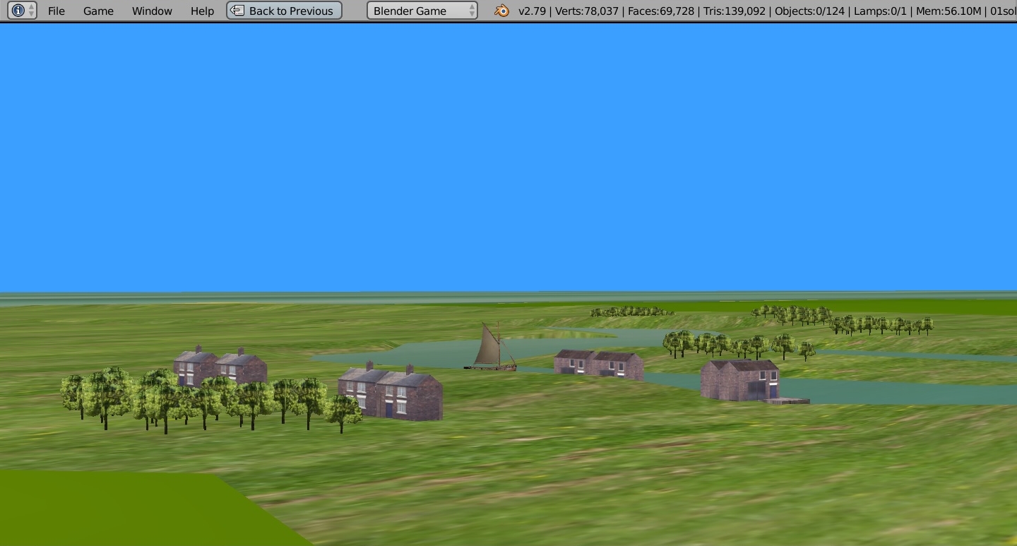
Next Looking towards Annan in th far distance
from Port Carllsle.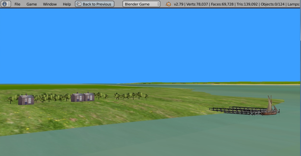
era early 19th century pretend.
2 Likes
Apparently there is just me on the these forums who make maritime routes. So not really suitable for me to continue.
I think it best for me to pause downloads again.‘If’ Forum interests expand from just small games and art work I might resume maritime downloads. After two year ‘test’ run I think this still applies. B
To keep up to date you would need to refer to site. (if/when available)
B